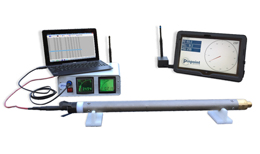
The Probe
The Steering Tool System incorporates a directional probe, connected to a computer on the surface via electric cable and software that provides a real-time deviation-control information (toolface, inclination and hole direction) for precise calculation of the borehole position.
The probe uses tri-axial accelerometers and magnetometers to measure the earth's gravitational and magnetic field.
These measurements are continuously updated every second on surface computer and DDU (Drillers Display Unit). During the drilling process, this data is transmitted by a single conductor cable (6 mm2) to the surface computer.
The software converts these data into Magnetic field data.
Magview
MagNav ™
The MagNav™ System is an active positioning system, using a ranging method triangularing on a artificial magnetic grid. For crossings, presenting particular difficulties, such as: canals, built-up areas, or rivers. The Magnav™ System, provided by experienced Pinpoint engineers, can be used in conjunction with the steering tool to allow the driller to control downhole steering with pinpoint accuracy.
Grids of cable -as many as are deemed necessary- are laid on the surface (water) in the desired direction of the crossing. By momentarily artificially creating a magnetic field, it is possible to locate the steering tool probe below the grid. The probe senses the magnetic field, and then transmits the field strength and direction values to the surface computer.
Sophisticated software then calculates three dimensionally the probe's position below the grid, on a X,Y,Z basis, thus locating the tool in relationship to the grid's center. This real-time position is then used to verify the B,H,A coordinates that have been calculated from the entry point using standard borehole survey techniques.
MagNav™ is an extremely valuable tool enabling positive location of the steering tool probe during the crossing. Course alterations can be made if required to ensure accurate punchout at the desired exit point.

Magentotaxis
Magnetotaxis is the ability in nature to orient yourself to a magnetic field. Known from pigeons and bacteria.
The main difference to the Magview™ system is the use of an AC current to power the grids.
This way several hundred meters can be covered.
This system is unaffected by disturbance from local high power cables or railroad.
Parallel Drilling
The Magnetotaxis Parallel Guidance System
The Magnetotaxis parallel system can be compared with the MagNav™ system, but instead of using a grid it uses a cable for reference. This cable can be positioned in any hole or pipeline near the project to drill [fig. 1]. This is a synthetic pipe. The artificial magnetic field created by this cable -when activated- can then be used to calculate the position of the drillhead in relation to this cable [fig. 2]. This works very much like the MagNav™ system. Great advantage of this system over the MagNav™ system is that the reference source is closer to the sensors so less disturbance is encountered.
A variety of sizes is available depending on the radial distance required. With the Magnetotaxis system you have the best quaranty that drilling can be done safely parallel to an existing pipeline without the danger of damaging it.
Report
After the borehole has been succesfully drilled, Pinpoint will provide a detailed survey based on data gathered throughout the project. This report will show the precise location of the borehole. The exact entry and exit points are measured from fixed points in the direct vincinity.

Fig. 1

Fig. 2
ABOUT PINPOINT
Pinpoint
Pinpoint Engineering provides highly accurate steering service for your drilling operation.
Over 20 years of knowledge and experience, inhouse research and development of hard- and software.
History
Pinpoint Engineering BV is the continuation of the “Rivercrossing” department of Sperry-Sun Drilling Services.
Sperry-Sun was a directional services company specialized in controlling deviated drilling operations in the oil and gas industry. For this Sperry-Sun has developed its own line of special tools and software.
In the eighties Sperry Sun was asked to apply its special services in the pipeline drilling operations, usually a pipeline crossing under a river. When this proved to be successful the tools and software were adjusted to fit the special needs in the rivercrossing industry.
This sideline service was so successful that a special section was created to focus on the Rivercrossing market. The result was a group of highly specialized engineers with specific survey tools and systems.
In the beginning of 1999 Sperry-Sun was taken over by Halliburton.
In the strategy of Halliburton there was no place for this product so the department was sold off and Pinpoint was founded.
With the experience of more than 15 years and all the special products available we can now offer you the best services and guide your drilling operation to the most difficult targets.

CONTACT INFO
VISIT US
Pinpoint Engineering
Vitus Beringstraat 5
7825 AH Emmen
MAIL US
info@pinpoint.eu
Pinpoint Engineering
Flintstraat 22
7815 RG Emmen
CALL US
+(31) 591 648 643
INFO
Kvk Meppel 04059718
BTW NL 80.81.29.132.B.O1
IBAN NL 07 RABO 011 6803 061
